The last few days of the class our group was tasked to take what we learned in the class and apply it to a design project in San Luis Obipso. The following link is to our presentation and comments on our design: http://psudelft2015alexsandoval.blogspot.com/2015/07/design-project.html
Check it out!
Thursday 23 July 2015
Friday 17 July 2015
Transportation things I wish we had in the US
After spending over two weeks in the Netherlands, I feel like I have an adequate understanding of the transportation network. The following three were interesting to me along the trip!
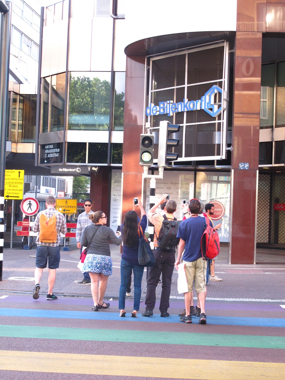
1. Unique Intersection Treatments
Rabbits and girls with ponytails in the pedestrian signal head, or rainbow colored pedestrian striping would never be allowed in the US without special exception but these treatments put a smile on us transportation nerds faces as well as all the other people using this intersection.


2. Wait Time Count Down Pedestrian Head
This is a treatment that could be easily implemented in the US. "Wacht" means wait in Dutch and the white LED lights surrounding the "Wacht" give the pedestrian some indication of how much time they need to wait. Letting the pedestrians know when they are getting the go ahead to cross the street could cut down on people illegally crossing the street. This treatment would work well at pre-timed signals where all the signal timing is set ahead of time. Our group mainly saw these in urban cores where there were a lot of pedestrians and the signals are probably pre-timed.

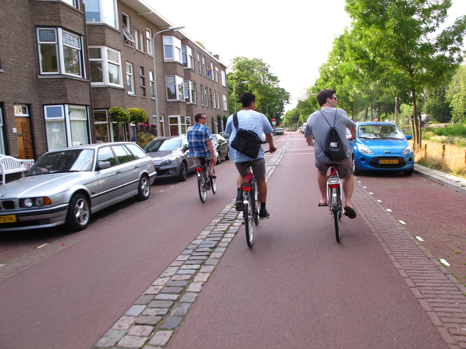
3. Two-way Cycle Tracks
I know these exist in the US, but I wish there were more. The two way cycle tracks are less stressful to use than bike lanes, especially if the auto's speed limit is over 30 mph. I enjoyed using them as well as our group. The two-way cycle track gives cyclists the flexibility to ride side by side if there isn't oncoming bikes, and . Proper intersection design ensures cyclists safety when crossing opposing traffic streams. I hope to incorporate them in my street designs in my career.

1. Unique Intersection Treatments
Rabbits and girls with ponytails in the pedestrian signal head, or rainbow colored pedestrian striping would never be allowed in the US without special exception but these treatments put a smile on us transportation nerds faces as well as all the other people using this intersection.


This is a treatment that could be easily implemented in the US. "Wacht" means wait in Dutch and the white LED lights surrounding the "Wacht" give the pedestrian some indication of how much time they need to wait. Letting the pedestrians know when they are getting the go ahead to cross the street could cut down on people illegally crossing the street. This treatment would work well at pre-timed signals where all the signal timing is set ahead of time. Our group mainly saw these in urban cores where there were a lot of pedestrians and the signals are probably pre-timed.

3. Two-way Cycle Tracks
I know these exist in the US, but I wish there were more. The two way cycle tracks are less stressful to use than bike lanes, especially if the auto's speed limit is over 30 mph. I enjoyed using them as well as our group. The two-way cycle track gives cyclists the flexibility to ride side by side if there isn't oncoming bikes, and . Proper intersection design ensures cyclists safety when crossing opposing traffic streams. I hope to incorporate them in my street designs in my career.

Wednesday 15 July 2015
The 2nd Best Roundabout in the History of Roundabouts
On one of our groups introductory rides, Dr. Bertini brought us to this roundabout which is only a 5 minute bike ride from my apartment.
Why is the roundabout special?
1. Its a roundabout
2. It has a two-way cycle track around it where the cars yield to the bicyclists before they ENTER AND EXIT the roundabout
3. Its near a mall so it sees a lot of daily traffic
4. Beautiful landscaping
5. THE TRAM LINE RUNS RIGHT THROUGH THE MIDDLE OF THE ROUNDABOUT!!!!!!!!!!!!
6. Someone put a fake cow on it (pretty adorable)
Yes, you read me right. The roundabout has the tram line running through the middle. Don't believe me? They say a pictures worth a thousand words.....


I also decided to take a video to show how the roundabout operates. The roundabout operates like a traditional roundabout. When a tram or a bus approaches bells start to ring and the signal heads come on stopping vehicles performing conflicting movements from entering or exiting the roundabout. All other movements are free to continue on, business as usual. The tram and buses have dedicated right of way through the middle of the roundabout. When the tram or bus exits, the lights turn off and the roundabout functions normally again. Here is the link to a video I took while visiting the roundabout: http://youtu.be/ZF1likLoQ3c
Photo Assignment
Hello everyone! On July 8th, our class broke into two groups and rode our bikes to a small community 4 km outside of Delft called Rijswijk. Riswijk is a smaller town with 48,000 residents with a historic old town, new city center, and residential neighborhoods. Our group visited 10 sites around Rijswijk. Throughout the day, I took some photos which are below.
1. Delftweg - "Delft" - "way"
This is the old road to connecting Delft to Den Haag. Rijswijk is in between Delft and Den Haag. This road is very bike friendly with a two-way cycle track and one vehicle travel lane in each direction. As a traffic calming measure, a "bayonet" was installed to reduce speeds and limit the volume on this road. The roadway width in the bayonet is reduced to around 10 ft so only one car can pass through the treatment at a time. The extra space was converted to parking spots. Priority is given to the northbound traffic.


6. Old Rijswijk City Center
The old city center of Rijswijk was outgrown when the population spiked 50 years ago. Its current location offered no room to expand so a new city center was built. The old city center still kept it charm and became a bike and pedestrian zones. The businesses in the old city center are reaping the economic benefits of the bike and ped zone.


7. General Spoorlan Road Diet
General Spoorlan received a road diet a fews years back. Now there is only 1 lane for through traffic in each direction. The extra space in the roadway was converted to a park.


8. New Town Center and Eisenhowerplein.
The new town center is built around the Eisenhowerplein which is the location for the new underground train station, major tram and bus stops, office and apartment buildings, and shops.

1. Delftweg - "Delft" - "way"
This is the old road to connecting Delft to Den Haag. Rijswijk is in between Delft and Den Haag. This road is very bike friendly with a two-way cycle track and one vehicle travel lane in each direction. As a traffic calming measure, a "bayonet" was installed to reduce speeds and limit the volume on this road. The roadway width in the bayonet is reduced to around 10 ft so only one car can pass through the treatment at a time. The extra space was converted to parking spots. Priority is given to the northbound traffic.
 |

2. Bike Bridge "Do Oversteek"
The Haagweg runs parallel to a large shipping canal. This pedestrian and bicycle swing bridge provides great connectivity to the communities living around the canal to services, employment centers and transportation options on either side of the canal. We had to opportunity to watch bridge swing out when a boat rode along. It only took a 4-5 minutes for the bridge to swing open and allow the boat to pass and was very quiet.


3. Rembrandtkade and Populierenlaan Bike Route
This is a residential street that was recently improved to become a part of the newly created bike highway between Delft and Den Haag. The following pictures show the newly designed sections of this street. There is one lane for vehicles to access the adjacent homes, with parking on either side with 1 tree positioned in the parking lane per two parking spaces. The adjacent canal also gives this neighborhood a calm and relaxing feeling with a footpath on the other side.


4. Hoornbrug and Haagweg
Haagweg used to have two travel lanes in each direction with the tram tracks in the middle. The new design incorporates residential parking, sidewalks, access route for houses, 1 separated travel lane in each direction, and new tram tracks to accommodate newly purchased wider trams. The city is currently in the construction phase.


5. Da Costa Neighborhood
Da Costa neighborhood was a Dutch experiment. There was a lot of cut through traffic so the City installed traffic calming devices to discourage cut through behavior. The speed humps slow traffic down midblock, and at some of the intersections, through vehicular traffic is not permitted. Vehicles must either turn left or right onto one way streets while the cyclists can continue through.


The old city center of Rijswijk was outgrown when the population spiked 50 years ago. Its current location offered no room to expand so a new city center was built. The old city center still kept it charm and became a bike and pedestrian zones. The businesses in the old city center are reaping the economic benefits of the bike and ped zone.


7. General Spoorlan Road Diet
General Spoorlan received a road diet a fews years back. Now there is only 1 lane for through traffic in each direction. The extra space in the roadway was converted to a park.


The new town center is built around the Eisenhowerplein which is the location for the new underground train station, major tram and bus stops, office and apartment buildings, and shops.
 |
| Protected Intersection |

 |
| Sky-lights for the underground train station |
Thursday 9 July 2015
Initial Impressions
I have had almost a week in the Netherlands now, so it seems as best a time as any to take the time to talk about my first impressions of the Netherlands. One of my hobbies is photography so I thought I would use the pictures I have taken to illustrate my points.
 |
| The bike in the front is mine. It is black single speed bike. The red seat cover is water proof and keeps the rain off. The panneers are super helpful for carrying all my stuff in and a lot of bikes have them here. I also have a flowery bell on it for when I am passing people. Also, all the bikes here have this nifty back wheel lock. It takes a little longer to lock my bike up but its pretty cool. Also, THERE ARE BIKES EVERYWHERE! A lot of people (I am assuming college students) will just abandon their bikes and lock the back wheel and then go to class or into a shop. We were told we had to lock our bikes to something that "can't get up and walk away", hence the light pole (just for the first day, then I found the bike racks). When I first got the bike I was really apprehensive riding over 150 miles in the next two weeks with only one gear but now it feels normal. Most of the bikes here don't really have too many gears (and many are old and crappy) so it blends in and so do I! I am getting the true Dutch experience and I am loving every minute of it. |
 |
| This is the canal and draw bridge right behind my apartment building. So beautiful. Also, everything is so green and alive! So not like California right now.... |
 |
| The Dutch rarely paint their bike lanes like in the US. The color red is reserved for bike facilities. Typically you will see instead of red paint to show where the bikes facilities are, the asphalt will be red! I asked a Utrecht city official and he couldn't tell me how much if costs to make the asphalt red but he did say it cuts down on noise so that is why it is sometimes used in newer residential neighborhoods. |
 |
| The other think the Dutch do is use different paver design to delineate bike lanes, or travel lanes. I think it gives the streets character! |
 |
| This is the bike parking in the Utrecht train station. This facility can hold over 7,500 bikes and it was full when we looked at it! I don't have a picture of any trains but the train system is really easy to use too! |
 |
| This bridge is pretty cool! Its a bike-ped suspension swing bridge! We also got to watch it open this morning. I was amazed how quickly is swung and how quiet it was. The whole process only took a couple of minutes. |
 |
| Can't have a blog about the Netherlands with a cameo from a windmill! |
 |
| Our group doesn't stop as often as I would if I were traveling alone (to take pictures of cools things) so I have gotten really good at taking pictures while riding my bike at the same time! |
 |
Canal life is a beautiful thing, especially if you have a stroopwaffle in your hand! |
 |
| Dutch salad pancake! My first dutch dinner! |
Facility Assignment Number 2: Underpasses, Bike Lanes, and Advisory Bike Lanes
Hello all 3 people that read my blog! On July 7th, our class broke into groups and rode our bikes around the city to look at 3 underpasses, Netherlands' bike lanes and advisory bike lanes. The follow post are the main points from our groups final report which can be found here: <link will be inserted soon>
Underpasses
The following are some key design elements noticed in the underpasses we visited.
- the ramps length is balanced between the grade and available space
- proper lighting in the underpass so no one can hide or so anything shady
- should be able to see all the way through the tunnel
- eliminates the conflicts between opposing vehicle traffic and the bicyclists and pedestrians
- increases permeability for residents and commuters in the community. Underpasses are spaced around 500 meters from the next crossing.
Bike Lanes
The following are some design elements and observations about bike lanes:
- bike lanes are a space on the roadway for bicycles that are only separated by traffic by a stripe
- bike lanes in the Netherlands function similarly than US bike lanes
- on average 6 ft wide
- the drainage area/curb/gutter is much smaller than in the US so the bike lanes feel larger. It was much easier to ride next to a friend
Differences than US bike lanes
- painted/colored asphalt color = red
- well maintained markings
- the bike lanes are respected by drivers
- occur on lower speed streets (> 30 kph). If the road is over 30 kph, then a cycle track would be installed
- better lighting, better designated bike lanes at intersections
- bikes have their own signals
- the drainage gates are smaller than your wheel so you don't get caught in them
Advisory Lanes
The following are some design elements and observations about advisory bike lanes:
- this treatment is typically found on local roads with little vehicle traffic. The advisory bike lane is striped with a
- gives the bikes a space even when there isn't room for a protected bike space.
- no centerline on the roadway forces the cars to slow down when passing opposing vehicles
- acts as a traffic calming measure to slow the vehicles down when two cars try to pass each other. The because the advisory bike lanes are striped with a dotted stripe cars can swerve into them if needed
- The cars waited for a gap to pass other vehicles and bikes
- great for streets with low vehicle volumes, and a speed limit under 30 kph
Underpasses
The following are some key design elements noticed in the underpasses we visited.
- the ramps length is balanced between the grade and available space
- proper lighting in the underpass so no one can hide or so anything shady
- should be able to see all the way through the tunnel
- eliminates the conflicts between opposing vehicle traffic and the bicyclists and pedestrians
- increases permeability for residents and commuters in the community. Underpasses are spaced around 500 meters from the next crossing.
 |
| Hoventunnel which goes under a roadway |
The following are some design elements and observations about bike lanes:
- bike lanes are a space on the roadway for bicycles that are only separated by traffic by a stripe
- bike lanes in the Netherlands function similarly than US bike lanes
- on average 6 ft wide
- the drainage area/curb/gutter is much smaller than in the US so the bike lanes feel larger. It was much easier to ride next to a friend
Differences than US bike lanes
- painted/colored asphalt color = red
- well maintained markings
- the bike lanes are respected by drivers
- occur on lower speed streets (> 30 kph). If the road is over 30 kph, then a cycle track would be installed
- better lighting, better designated bike lanes at intersections
- bikes have their own signals
- the drainage gates are smaller than your wheel so you don't get caught in them
 |
| Typical bike lane in Delft |
The following are some design elements and observations about advisory bike lanes:
- this treatment is typically found on local roads with little vehicle traffic. The advisory bike lane is striped with a
- gives the bikes a space even when there isn't room for a protected bike space.
- no centerline on the roadway forces the cars to slow down when passing opposing vehicles
- acts as a traffic calming measure to slow the vehicles down when two cars try to pass each other. The because the advisory bike lanes are striped with a dotted stripe cars can swerve into them if needed
- The cars waited for a gap to pass other vehicles and bikes
- great for streets with low vehicle volumes, and a speed limit under 30 kph
 |
| Advisory Bike Lane on a residential street |
 |
| Advisory bike lane where the space designation changes are made with red asphalt and bricks |
Tuesday 7 July 2015
Delft Facilities Tour Assignment One 7-6-2015
Assignment Background
The class was split up into a group of 5 Northeastern
students and 2 Portland State students with one of the professors leading the
group to 5 different facility types in Delft: a two-way cycle track with raised
crossings, a Woonerf (a living street) and 30kmph zone, a single lane
roundabout, a bike boulevard, and a large protected intersection. My particular
group was led by Peter Koonce. Our
group visited all 5 of these locations, discussed the facilities and took
photos. We were assigned to look at 3 of
the facilities and document our overall reactions and suggest one specific
location in the US where this facility might be applicable.
Location A:
Two-Way Cycle Track
On larger streets in the Netherlands, engineers design cycle
tracks to separate (with a hard barrier) cyclists from vehicle traffic. The two intersection directly below show the location
of this two way cycle track and the photo shows street view from our visit
today. As you can see the cycle track is two way for bicycles and is only on the
west side of the street. The barrier
happens to be a hard curb and then a parking lane for cars.


This is a great concept if the street is wide enough of
right of way acquisition is not difficult. Separating the cyclists from the road
traffic reduces stress for the cyclists and makes it safer for young and
elderly riders especially. The raised
cycle track also increases the visibility of cyclists when they reach
intersections. I really like riding my
bike along cycle tracks and I see the value for all cyclists in implementing
them. With a two way cycle track, the
engineer consolidates the buffered area as opposed to having one way cycle
tracks on each side of the roadway. I personally
like two way cycle tracks because there is a sense of flexibility for the rider
and gives cyclists the opportunity to ride next to a partner when there isn’t
opposing bike traffic.
USA Implementation
I think Foothill Boulevard between California Boulevard and Patricia
Avenue in San Luis Obispo is a perfect location for a two-way cycle track. The following images show an aerial of Foothill
Boulevard outline in green and a typical cross section Foothill Boulevard. Foothill Boulevard is a perfect street for a
cycle track because the speed limit is 35 mph which makes the speed
differential between bikes and cars large, also it is an arterial that connects
two large residential neighborhoods to Cal Poly’s campus which leads to large
bicycle volumes at all times of the day as well as large traffic volumes, and
there is limited right of way so combining the cycle tracks together saves
hardscaped buffer space.
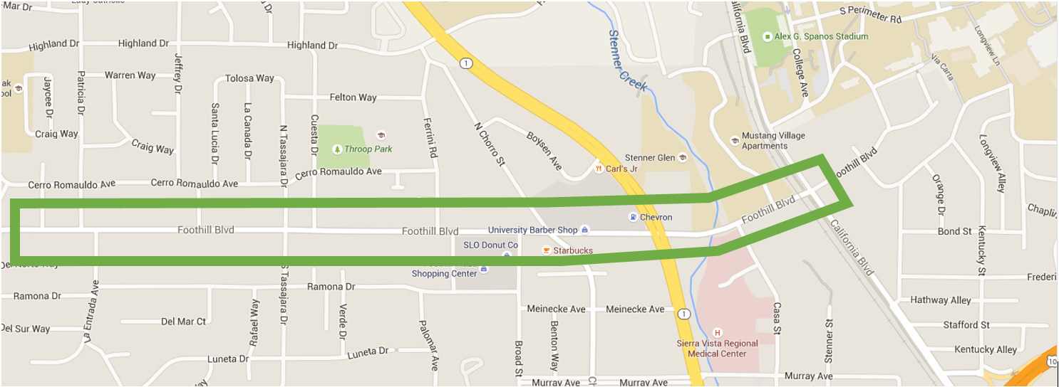

The two way cycle track would promote good bicycle riding
behavior and encourage younger students living in these two neighborhoods to
cycle to school as well as keep them safe.
There are too many bicycle accidents along this corridor and installing
the two-way cycle track would hopefully eliminate those bicycle-car crashes. Also, many times, an observer will see young
adults cycling the wrong way in the current bike lanes mainly on the north side
of the street so implementing a two-way cycle track would eliminate any
conflicts with riding the wrong way.
Location C:
Single Lane Roundabout at Westlandseweg and Zaagmolen
Roundabouts are an intersection treatment to help users navigate
opposing traffic streams. The particular
roundabout studied also had a cycle track around the automobile travel lanes
which separates the bicycles from the automobiles. The single lane keeps bicyclists and
pedestrians safe from potential collisions from cars from multiple lanes. The flared entry acts as a traffic calming
measure to slow the vehicles down before entering the intersection and also
gives them time to yield to any pedestrians or bicyclists crossing. The landscaped medians serve as pedestrian
refuges enabling pedestrians to cross one traffic stream at a time and also
give space for automobiles to yield to bikes crossings too. The three
images directly below show the aerial view of the roundabout visited and photos
taken during the site visit.


It has been thoroughly researched and documented that
roundabouts increase safety for all users.
The cars enter the roundabout slower than a signalized intersection and
there are few conflict points for users to get into crashes. It was very interesting for me to visit this
roundabout because I have never seen a roundabout with a cycle track. In the US, bicycles are treated like a second
class mode and normally pushed to the side, making then a stressful
intersection to bike through. I felt
very safe biking around this roundabout and I really wish we had these in the
US. The striping makes it easy for all
vehicles and pedestrians to understand where each’s space is and to yield when
appropriate while still not blocking other traffic streams. I really think it is brilliant and it was
nice to see school age children using the roundabout biking either to or from
school without parents because they felt safe.
USA Implementation
I think the intersection of Chorro Street and Palm Avenue would
be a good candidate for roundabout with a cycle track. This intersection is close to San Luis Obispo’s
downtown with a lot of vehicle, bike, and pedestrian traffic. Separating each mode would decrease the
number of accidents and the accident severity at this intersection. This intersection is close to one of San Luis
Obispo’s high schools which would hopefully encourage bike riding to and from
school. The following two pictures are
the aerial view of the intersection in relation to San Luis Obispo’s downtown and
the street view of two of the intersection approaches for the intersection.


It is imperative to maintain safe connections for residents
from the neighborhoods to the City’s economic center. I think upgrading this intersection to a
single lane roundabout with a cycle track on both Palm and Chorro would
facilitate more bicycle activity in this area which would ultimately be good
for businesses and the resident’s health.
The roundabout could reduce delay, reduce accidents and crash severity,
and facilitate safe crossings for bicyclists and pedestrians.
Location E:
Protected Signalized Intersections
Our group visited the signalized intersection of Ruys de
Beerenbrouckstraat and Princes Beatrixlaan.
This intersection is a very large intersection with cycle tracks for the
bicycles. The bicycles are given their
own phase to cross to eliminate the conflict with the right turning
vehicles. The refuges in the middle of
the intersection decrease the travel time for the pedestrians because they only
have tocross one stream of traffic at a time and therefore decrease the total
cycle length for the intersection. Also,
unique to the Netherlands, the bicyclists have a “WACHT” sign (WAIT sign) which
illuminates when the bicycle push button is pressed. Small white LED’s also illuminate around the “WACHT”
sign which count down the number of second the cyclist has to wait. Because there is a cycle track, bicycles make
a left turn in two phases which eliminates conflicts with automobiles and is
much safer. The three images directly
below show the aerial view of the intersection visited and photos taken during
the site visit.


Using this intersection as both and pedestrian and bicycles
was very easy. The pedestrian refuge was
wide enough I didn’t feel uncomfortable waiting the second pedestrian signal to
turn green. Also, as a bicyclist it was
really neat to see how much waiting time was left before the light turned
green. I really wish we had those
countdown bicycle and pedestrians signal heads to countdown how much waiting
time is left. These little heads cost
about $700 - $800 per unit and I really think it would enhance the pedestrian
and bicyclist experience.
USA Implementation
I think the intersection of Santa Rosa and Foothill could
use the concepts discussed above. The
cycle track would make crossing this very wide intersection easier and safer
for bicyclists. This intersection sees
many cyclists throughout the day because it is adjacent to medical offices, the
hospital, and Cal Poly. Adding a refuge in the middle of the
approaches would reduce the required green time for pedestrians to cross the
street because the pedestrian refuge would give them a safe place to stop. The
following two pictures show the aerial view of the intersection and a street
view’s current conditions.


Subscribe to:
Posts (Atom)